Skip to content

Post aus Kanada

CA-24276

Bei dieser Karte lese ich immer Neufünfland. Der richtige Absendeort ist jedoch Neufundland. Das ist ein Teil Kanadas und grenzt an den Atlantik. Auf der Insel Neufundland liegt unter anderem der Ort Cape Sear. Das ist der östlichste im gesamten amerikanischen Kontinent. Danach kommt in Richtung Osten erstmal viel Wasser.

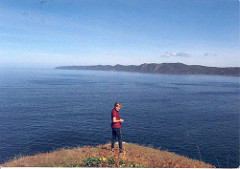
Die Karte ist selbst gemacht. Auf der Abbildung sieht man die Cousine des Absenders. Es steht leider nicht dabei, wo das Foto aufgenommen wurde. Und Neufundland bietet mit mehr als hunderttausend Quadratkilometern Fläche und den vielen Fjorden zahlreiche solche Aussichtspunkte.

Trackbacks

No Trackbacks

Comments

Display comments as Linear | Threaded

No comments

Add Comment

Enclosing asterisks marks text as bold (*word*), underscore are made via _word_.
Standard emoticons like :-) and ;-) are converted to images.
BBCode format allowed
E-Mail addresses will not be displayed and will only be used for E-Mail notifications.

To prevent automated Bots from commentspamming, please enter the string you see in the image below in the appropriate input box. Your comment will only be submitted if the strings match. Please ensure that your browser supports and accepts cookies, or your comment cannot be verified correctly.
CAPTCHA

You can use [geshi lang=lang_name [,ln={y|n}]][/geshi] tags to embed source code snippets.
Form options
cronjob